A May 2022 RADARSAT Constellation Mission satellite image of fields in Manitoba, including many affected by flooding. Adoption of satellite imagery in agriculture is seen to have lagged compared to other sectors.

Farm focus needed for eyes in the sky

An ag expert with NASA talks about why on-farm adoption of satellite imagery has lagged

Satellite imagery has potential to revolutionize agricultural management, but that isn’t likely to happen unless on-farm adoption rates increase, the head of a NASA-led consortium said during a recent event in Winnipeg. NASA Harvest executive director Alyssa Whitcraft told attendees at this year’s Canadian Crops Convention that use of satellite imagery has exploded in some […] Read more


An artist's rendition of a Landsat satellite in Earth orbit.

Checking crops from orbit may be underused option

The available satellite imagery of our crops may be an underused tool for field analysis

Glacier FarmMedia — Last fall on her farm near Holland, Man., Anastasia Kubinec was struggling with a decision about a canola field. In one part of the of the field, it seemed like the crop was ready to combine. But other areas were possibly too wet and too green. One option was going in with […] Read more

Drought has meant more demand for forage insurance, but accuracy of measurement based on local conditions is challenging.

Satellite-based insurance may be future of forage risk management

Analysis from above could be an accurate, timely way to measure forage growth

Glacier FarmMedia ­— Satellite-based insurance technology could be a way to protect beef producers during times of drought. There’s more interest in forage insurance during recent droughty times on the Prairies, but evaluating local forage risk is challenging. “Weather events are becoming more acute in severity and frequency, you know the drought of 2023, 2021,” […] Read more


The amount of damage caused by cutworm feeding on canola seed-treated with an insecticide was measured. Manned aircraft were used to collect images on 90 acres. Field and data analysis was performed to develop relative density, and per cent cover maps were created to provide an objective estimate of cutworm damage.

How to use remote sensing for crops to its fullest potential

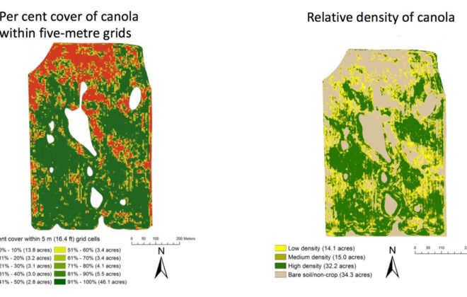
Images from drones and satellites can be part of a much bigger picture

Remote sensing tools can produce a lot of valuable information about what’s happening on farmland and within your crops, but the full potential has yet to be properly harnessed, says a north-central Alberta agronomist after studying the technology for a couple years. Satellite imagery, aerial photography and images captured by unmanned drones are all forms […] Read more

Drone provides a new field perspective

Drone provides a new field perspective

Ground truthing is still important, but drones can identify problem areas

Randi Wenzel says even basic operation of a drone over annual crops and pastures on their south-central Saskatchewan mixed farm provides some very useful management information, along with some peace of mind. Wenzel, who farms with family members south of Central Butte, has been flying a drone during the cropping and grazing seasons for the […] Read more


Illustration courtesy USGS

USGS finds more dirt for growing crops

Until we defrost Greenland this could be all we’ve got

Much like the excitement I feel when I find a missing sock behind the clothes dryer, I am sure that is what the US Geological Survey (USGS) experienced when it recently discovered more cropland in the world. And they didn’t just find one sock, it was a whole outfit. The USGS recently reported that further […] Read more