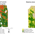
The amount of damage caused by cutworm feeding on canola seed-treated with an insecticide was measured. Manned aircraft were used to collect images on 90 acres. Field and data analysis was performed to develop relative density, and per cent cover maps were created to provide an objective estimate of cutworm damage.

How to use remote sensing for crops to its fullest potential

Images from drones and satellites can be part of a much bigger picture

Remote sensing tools can produce a lot of valuable information about what’s happening on farmland and within your crops, but the full potential has yet to be properly harnessed, says a north-central Alberta agronomist after studying the technology for a couple years. Satellite imagery, aerial photography and images captured by unmanned drones are all forms […] Read more

Three things to know about precision ag

Three things to know about precision ag

Q & A with an expert

Q: What are three common misconceptions about precision ag? A: A large amount of information can be generated in precision ag applications. This can lead to confusion, misunderstanding and frustration among farmers. Here’s a few common misconceptions about precision ag. 1. Will it break the bank to get involved with a precision ag program? The […] Read more


5G could be a game changer for farmers

5G could be a game changer for farmers

Improved access to rural broadband could reduce costs and increase productivity

Bill Campbell still does yield mapping with a pen and paper. The principal operator of Campbell Land and Cattle would like to use precision agriculture to monitor moisture levels, make decisions about inputs and improve yields on his fields of wheat, barley, oats, canola, flax, corn and pulses but broadband access on his Minto, Manitoba, […] Read more

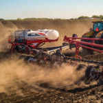
AGCO measured the impact of the precision planting features on its White Planter line on corn yields over a three-year trial.

AGCO proves precision features add value

On-farm trials show yield gains in the U.S. when new technology is added

Three years ago, AGCO decided to prove to its customers — and potential customers — that outfitting one of its White Planters with precision planting technology would offer them a payback in higher yields. The company organized a series of field trials across the Midwest and measured the impact of improving seed placement, and depth on yields. The trials involved […] Read more


farmer inside tractor cab

How precision ag tools can add value on the farm

Q & A with Nutrien Ag Solutions

Q: How can precision agriculture tools help manage farm data? A. Precision agriculture involves ever-evolving technology in crop production and farm management. Within the last several years, there has been an influx of interest around utilizing different components of precision agriculture. The introduction of GPS to farm equipment has enabled growers to more accurately and […] Read more

Data from Ceres Imaging can help farmers make in-season decisions.

New tech: Simplifying complex issues on the farm

New technologies are coming our way faster than ever. These 2 solutions use planes and ducks

Although huge strides have been made with technology in the agricultural industry with field mapping, GPS and even autonomous implements, other areas of farming have gone unchanged for far too long. With an increase in ag-focused Silicon Valley-style start-up companies popping up in Western Canada and the U.S. new technologies are finding their way onto […] Read more


From an equipment and technology perspective, decide what features are important to you.

Choosing a precision agriculture system

Before you cut the cheque, make sure the system you choose is right for your operation

Depending on which grower you ask, a “precision ag system” can mean anything from GPS-guided autosteer to advanced software that helps them manage just about every aspect of their farm. But with so many new technologies, software platforms, upgrades and equipment providers on the market, what basic principles do growers need to keep in mind […] Read more

The photo shows this old scribe in his young kid days giving advice to a farmer by phone — a very efficient way to do business back in the day when phones were answered. But, I was only able to help because the #12 Soils Map was right beside my phone. My first question was always, “Where are you from?” Then I could take a quick peek at the map and give a much better answer. Many thought I had the soils map in my head — 
but now the truth comes out.

Precision ag Step 1: soil maps

The most important part of precision agriculture is the soil maps of your fields


My first work on precision agriculture was actually in the 1960s and colleagues had been doing work on the idea before that. Back then it was all about identifying specific soil profile types in a field and trying to determine if their variable properties could be managed differently. Some things were clear: 1. Leached (white […] Read more


Ag orgs build open-source data platform

Ag orgs build open-source data platform

Collecting data is one thing, but pulling it into one place brings it to the next level

The advent of precision agriculture technology and the Internet of Things has led to the collection of vast amounts of data. Many different types of tools, equipment and devices gather data on everything from crop yields to how many steps an animal takes in a day. Much of that data, however, is under-utilized and is […] Read more