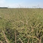
An artist's rendition of a Landsat satellite in Earth orbit.

Checking crops from orbit may be underused option

The available satellite imagery of our crops may be an underused tool for field analysis

Glacier FarmMedia — Last fall on her farm near Holland, Man., Anastasia Kubinec was struggling with a decision about a canola field. In one part of the of the field, it seemed like the crop was ready to combine. But other areas were possibly too wet and too green. One option was going in with […] Read more


(Vonkara1/iStock/Getty Images)

StatCan releases satellite crop vegetation data

MarketsFarm — Statistics Canada’s crop condition assessment program (CCAP) on Thursday released its weekly normalized difference vegetation index (NDVI) values from April 11 to May 29 — telling the tale of weather extremes in the Prairie provinces. As of the fourth week of May, seeding was 95 per cent complete in Alberta, compared to the […] Read more