
Blair Ford and Colette Thurston have been seeing their east-central Alberta farm from a whole new perspective over the past year and a half.
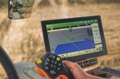
Using an online program, they’ve got all 2,300 acres mapped, and throughout the growing season regularly receive satellite imagery showing variations in crop colour (a vegetative index) that can alert them to a wide range of changing conditions. Changes can be related to moisture, or differences in soil types, or lack of fertility, or pest problems such as weeds, disease and insects.
Those images themselves don’t change anything, but it alerts this farming couple in the Wainwright/ Irma area of Alberta to do some ground truthing to determine what is happening in specific areas of their fields. Is it a pest problem they, perhaps, should deal with immediately, or an area to watch and apply a change of management for next season?
Read Also
Croptimistic’s SWAT Cam maps one million acres in Western Canada
Croptimistic’s SWAT Cam has mapped more than one million acres, using sprayer-mounted cameras to generate crop and weed maps that support in-season analysis and future management decisions.
Since some of their land is eight to 10 miles apart, the daily weather reports they also receive as part of the service, showing rainfall, temperature and wind speed, are very useful, too, in deciding whether conditions are right for field operations such as seeding, applying crop protection products or combining.
Along with keeping a detailed record of field operations and treatments, as well as yield data, the program also provides the farmers with the tools to develop their own prescriptions for spot treatments and, eventually, as they upgrade their own farm machinery, they will be able to create their own variable-rate-treatment (VRT) prescriptions for seeding and, perhaps, herbicide and fungicide applications.
Those are just some of the features of the Climate FieldView app and website Ford and Thurston began using in late 2020. Aside from being comprehensive in terms of field monitoring, record- keeping and data collection, bonus features of the online program are it is also very affordable and, perhaps best of all, easy to use. (On the office computer, for example, you can access the Climate FieldView website and you can also download the app to your smartphone or tablet.)

“I haven’t used any other program that is similar, so I don’t have any comparison,” says Ford. “But we have found it very easy to use. Once you get registered and signed in, you just follow the prompts.” There is technical support available as needed.
He and Thurston were born and raised on their respective farms at Wainwright and nearby Irma, and they now operate a blended, mixed farming operation that includes a 100-head purebred Charolais operation, along with annual cropping of canola, hard red spring wheat, CPS wheat, barley and oats.
The Climate FieldView app was introduced by Bayer CropScience a few years ago, and each year it gains more subscribers, says Rob Makowsky, digital integration specialist with Bayer, based in Saskatoon, Sask. (If you join the BayerValue Rewards program, a subscription with access to Climate FieldView is free, otherwise a full subscription is $149 annually.)
“It is a very popular tool that helps farmers fine-tune their management,” he says. “It is easy to use and the technology is valuable in terms of field scouting and record-keeping. The satellite imagery (variations in vegetative colour) can identify areas of the crop a producer may want to take a closer look at on the ground. As you are out there walking or seeding or spraying, for example, you can also drop a ‘pin’ or create a digital marker in the program indicating this is an area you want to have a closer look at later. You don’t have to remember every detail. And later on, with the app on your smartphone, the GPS feature will lead you back to that exact spot for a closer look.”
The digital pins are also useful for marking out parts of the field for on-farm research trials. For example, the digital pins can identify an area of the field where a different treatment was applied — different seeding rate, different variety, or the application of a new crop protection product. In the fall, with the Climate FieldView program on your tablet, you can plug the tablet into the combine computer system and it will be able to identify and collect yield data specific to those flagged areas.
That type of management fine tuning fits well with a message from another Bayer specialist, Tim Gardner, a market development agronomist. While all companies are glad to sell you more product, Gardner says, first and foremost, farmers need to be profitable and apply management practices that improve their return on investment (ROI).
Gardner says while there seems to be several interpretations of the term “sustainable farming practices,” he sees it as applying responsible management practices that provide a decent return on investment.
“As you look at overall crop management as input prices increase, improving that return on investment may involve fine tun- ing management with more specific or spot treatments rather than a blanket operation,”saysGardner. That’s where he says a program such as Climate FieldView becomes a useful management tool.
“With satellite imagery, perhaps you can identify problem areas, or certain areas of the field with weed patches, for example, and adjust your program just to treat those patches,” he says.

Guided by the satellite imagery, a producer can check specific areas of a field to identify a weed patch or a particular weed spectrum and tailor the herbicide application to deal with those patches rather than the whole field. Similarly with fungicide, the vegetation index can indicate those areas of a field most prone to disease development. “You can treat those high-risk areas while, perhaps, 20 per cent of the field doesn’t need to be treated,” says Gardner. “That could be an appreciable savings on fungicide costs.”
And he says don’t rule out that sometimes strategic tillage might be a very useful tool in managing a weed patch or other problematic field condition. The point being made by Gardner — that farmers have a wide range of treatment options available, and by using management programs such as Climate FieldView as a guide, not every treatment needs to be applied from fence post to fence post. A more targeted approach to applying inputs is not only responsible but has good economics.
Back on the Ford and Thurston farm, after one full season with Climate FieldView, the farm couple is looking forward to making greater use of the technology as a tool to improve their crop management.
“As we take over management of the farm, initially we were just very impressed on how easy FieldView is to use,” says Thurston. “We are not particularly tech savvy, but we found it very user-friendly.
“The satellite imagery, which is updated every few days, is a valuable visual tool that shows you what’s happening with your crop during the growing season,” she says. “It alerts you to areas that you want to check on the ground. It is a great field scouting tool. Being able to drop those pins (digital markers) is really useful, even if it is just to mark a rock in the field at seeding time that you want to come back and remove later on.”
Ford says they have already used the Climate FieldView app to do side-by-side yield comparisons of different canola varieties, and as they upgrade seeding and field spraying equipment that includes variable-rate technology, he hopes to develop their own prescriptions for variable-rate seeding, fertilizing and perhaps even fungicide application.