
Croptimistic Technology, based out of Naicam, Sask., perhaps better known by its SWAT Maps brand name, is launching two new services in 2022 to make it easier and more affordable to map the soil and topography of the whole farm, and then literally view every acre of the crop during the growing season.
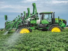
SWAT Cams is an innovation being offered in a limited rollout for the coming season to SWAT Maps clients. SWAT Cams involves mounting cameras on either end of the field sprayer boom to photograph virtually every acre of the growing crop each time the sprayer is used.
The cameras will capture images of the crop every 50 feet and that information will be fed directly into the Croptimistic server, then into a machine-learning algorithm the company has been developing in conjunction with the University of Regina.
Read Also
Deere taps startups to explore sensing, AI tech for farm uses
John Deere has named five companies to its 2026 Startup Collaborator Program, exploring emerging technologies for farm use including soil sensing, AI and predictive equipment monitoring.
“Ultimately, the goal is to develop crop and weed population maps directly related to the SWAT Map zones in the field,” says Cory Willness, Croptimistic’s CEO, adding it is another level of field scouting.
“If a farmer or agronomist is out walking and making a field check, they may check 10 different locations,” he says. “And it can be an added cost to have someone walking the field. This way, with the SWAT Cams, farmers can essentially do their own scouting across every acre each time they use the field sprayer and at a relatively lower cost.”
Willness says the primary goal right now is to get a more accurate data representation of how crops and weeds are establishing in the various production zones in their fields. Farmers will have the option to connect through the SWAT Maps interface to look at every image and, in the process, determine crop population by SWAT zone.
“They can see what kind of ground cover or biomass there is on a hilltop or a dry area and compare that with a mid-slope or low-lying area,” says Willness. “It won’t necessarily provide an exact plant count, but they can evaluate whether it is a low, medium or high biomass. This image has 40 per cent ground cover versus another image that has 80 per cent ground cover.
“Getting a better idea of how the crop establishes and the amount of biomass can help influence decisions, such as seeding rate, crop variety or fertilizer rate, for example,” he says. “If repeat images in a particular high-producing zone show a fantastic stand establishment, for example, the producer might be able to cut back on seeding rate and still have an excellent stand. It is information that could further help to fine-tune management decisions.”
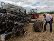
In the second service innovation, the company is also doing a trial run to make the SWAT Box soil sensor available to producers, so they can scan every acre on the farm during normal field operations. In the past, using the SWAT Box sensing equipment to scan the soil profile was something done by a trained crop consultant and often initially was only applied to a couple of fields or just part of the farm.
Starting with a limited release in 2022, Croptimistic Technology will make the SWAT Box available to about two dozen producers through a rental program. The SWAT Box can be attached to an air seeder, for example, so as the crop is seeded the sensor will be collecting data from every seeded acre — that’s not only comprehensive but much more affordable than paying a technician to cover each field with the equipment.
For more information visit the Croptimistic Technology website at swatmaps.com/croptimistic.