Note to readers: Before you read this article, I suggest you check back to page 14 of the April 15, 2013 issue of “Grainews.” The headline was “The Truth About Lake Winnipeg.” There will be some overlap with this piece.
Water quality
There are many aspects to water quality. For irrigation use, salt content is the most important, for household washing hardness is a big deal. For drinking water, total minerals, especially sulphate, is an issue. Low nitrate is important, especially for babies.
The most important aspect of water quality for human consumption has nothing to do with chemistry — it’s the biology. The disaster of E. coli contamination of groundwater at Walkerton, Ontario and the parasites in North Battleford, Sask., water sharpened the focus on water. In the decade plus since those outbreaks, all water utilities and regulators have upped the game substantially to prevent future events of those types.
Read Also

Is the technology in our vehicles a help or a hindrance?
Not only does new tech allow people to operate vehicles and farm machinery with fewer skills, it also creates more problems for vehicle users when those systems fail, Scott Garvey writes.
But the water quality issue we will deal with here is the issue with algal blooms on surface waters, particularly recreational lakes. It is now known that phosphorus is the main nutrient that is limiting in lakes. When the phosphorus level increases the algae have a picnic.
Back to the 70s: The Qu’Appelle River
When environmental concerns became a concern, the Qu’Appelle system in Saskatchewan was the subject of a major study. There were no intensive livestock operations at that time but Saskatchewan Agriculture did an inventory of all cows in the Valley. Some thought that all cows should be taken from upstream to keep the Qu’Appelle Lakes from getting algae in the hot “swimming” months.
The major study was completed and the results rest comfortably in a report in the government documents section of the University of Saskatchewan Library. It showed that over 90 per cent of the phosphorus in the lower Qu’Appelle system came from the cities of Regina and Moose Jaw. Shortly after that Moose Jaw converted to a sewage effluent irrigation system.
- Part 1 of Les Henry’s three-part series: Excess water and farm drainage
The big picture: Lake Winnipeg
In the past decade the large and ugly algal blooms on Lake Winnipeg have been a topic of much discussion. Folks that rely on Lake Winnipeg for resources or very important summer activities are justifiably upset. It took me a long time to realize that very low levels of phosphorus are all it takes to create a problem. So we must all be vigilant and do our part.
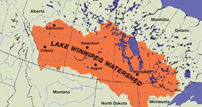
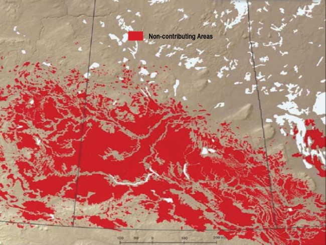
But let us first look at where that phosphorous comes from. Figure 1 (at the top of this article) shows a widely used, but misleading map of the Lake Winnipeg Watershed.
A December 2006 report to the Manitoba Minister of Water Stewardship entitled “Reducing Nutrient Loading to Lake Winnipeg and its Watershed” makes the following statement on page 13: “Within the Lake Winnipeg drainage basin, there are nearly 55 million hectares (jlh: 136 m acres) of farmland in the three Prairie provinces, of which more than half is under crop production and the vast majority is part of the Lake Winnipeg watershed.”
That statement is a very large misrepresentation of the actual situation.
Figure 2 shows non-contributing areas. All areas in red in Figure 2 (see below) do not contribute to external drainage, based on median annual runoff. In flat lands the area would be increased in high runoff years but even then very large areas have nothing to do with Lake Winnipeg. Large parts of “pothole country” have no connection to any external drainage.
The phosphorus load in Lake Winnipeg is sourced as follows:
- 47 per cent — Man.
- 33 per cent — the U.S.
- 12 per cent — Ont.
- 8 per cent — Sask./Alta.
- Very little would be from Alberta.
This data comes from a presentation made by Mark Lee, Manitoba Water Stewardship, to the newly-minted Assiniboine River Basin Initiative.
Phosphorus loading is well documented and any sources should be made as small as possible. But the work must be concentrated where the problem originates. For example, some recent research on the Pipestone Creek area of Saskatchewan has shown significant phosphorus losses from the field edge of bale grazing systems.
But, no one got on a horse or quad in spring to follow the water to see if any of it even reached the Pipestone Creek, let alone Lake Winnipeg. The first water body of concern on the Pipestone Creek should be Moosomin Lake. Lake Winnipeg is a long distance and many reservoir areas removed from the Pipestone.
Research on farm management practices to reduce phosphorus loss anywhere in the Canadian Prairies is simply too broad a brush and a waste of precious research funds.
Lake Winnipeg: The constipation theory
The Nelson River is located at the northeast corner of Lake Winnipeg and drains the lake to Hudson Bay. But, Manitoba Hydro has several hydro dams along that drainage route. Some folks claim that the flow restriction from the dams affects the residence time of water in the lake. That results in nutrient retention that “juices up” the algae. I have no basis or facts on which to base any opinion on that theory.
Lake Diefenbaker
In Saskatchewan we have three major dams on the Saskatchewan River system but Lake Diefenbaker is the most significant.
It is no surprise that Lake Diefenbaker is a stated priority for the University of Saskatchewan Global Institute of Water Security and the School of Environment and Sustainability. You can imagine my disappointment when I attended a grad student presentation dealing with phosphorous in Lake Diefenbaker. The project was trying to relate phosphorus levels in the Lake to fertilizer use statistics for the surrounding Saskatchewan crop districts.
The South Saskatchewan River in Saskatchewan is not even a river — it is a canal. (Credit for this goes to Kevin Shook, who used the canal label in a talk recently).
Very little of the water in the South Saskatchewan River or Lake Diefenbaker is added in Saskatchewan — 98 per cent of the flow originates from Alberta via the Oldman, Bow and Red Deer Rivers. They all join to become the South Saskatchewan just before entering Saskatchewan.
After the disappointing seminar, a few mouse clicks provided the answers I was looking for.
In 1998: 87.5 per cent of phosphorus in the Oldman River came from the City of Lethbridge. In 2000, after tertiary treatment by Lethbridge, the phosphorus contribution to the Oldman River was reduced to 23.6 per cent.
Similar numbers can be obtained for Calgary and the Bow River. With that kind of reduction one might expect a reduction in phosphorus load to the South Sask.
In 2012 the newly minted Water Security Agency of Saskatchewan produced a report entitled “ State of Lake Diefenbaker: That report said this about nutrient loading: “Nitrogen and phosphorus have been measured since the late 1960s by the Prairie Provinces Water Board (PPWB) at their Alberta/Saskatchewan border sites on the South Saskatchewan River and the Red Deer River. The length of this record allows for assessment of long-term trends. … The PPWB recently undertook such an exercise and found slight but significant decreasing trends for total and dissolved phosphorus concentrations at both the Saskatchewan and Red Deer River sites.”
Given the Alberta data showing major reductions in phosphorus load by cities the decrease makes sense. The details of that statement should be provided.
Soils in feedlot alley in Alberta are extremely high in available phosphorus. Alberta Agriculture and Environment folks have done a lot of good work in documenting the phosphorus in soils, surface water and groundwater of that area. But, as yet I have not seen an actual phosphorus load factor for that specific area.
The Future
In dealing with water quality issues we must use a rifle approach, not a shotgun. A quality problem must be traced back to the source(s) and dealt with at those sources. Describing non-point pollution as everywhere does not cut it. Generic research on an area that is not part of the problem is of little value. Water does run down hill and it can be traced. There has been a lot of doubtful research money spent on the basis that all of Canadian Prairie agriculture is somehow magically dumping all the way to Lake Winnipeg.
In Saskatchewan, Diefenbaker Lake is a priority for us, and monitoring work must be ramped up to at least what it was in the past. And, all information has to be readily available at the click of a mouse. Research work must first assemble and analyze all historic data. There is much useful data not being used.
The Assiniboine system is also a priority because what we do in Saskatchewan impacts Manitoba. As Saskatchewan drafts new legislation to deal with drainage questions the Assiniboine system will be a major priority.
None of us know how long this wet cycle will last. By the time we become more adept at handling the excess Mother Nature may well turn off the tap.