
The past few wet years have left some folks wondering if this is the new normal. What with Global Warming and all, perhaps we will have to live with these wet extremes.
What we fail to recognize is that our experiences — even old fossils like me — are but a very brief flash in the pan for Mother Nature.
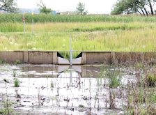
Eddie Balion’s Slough
Just east of my Dundurn farm is the R.M. of Lost River. It is in the heart of the Allan Hills upland with rough topography, many undrained sloughs and some sloughs that fill and spill in wet years. The “spill” goes no further than large sloughs in the level land north of the hills.
Read Also

Corn research looks for Manitoba-based weed control
Manitoba corn growers rely on U.S. or Ontario weed control recommendations. University of Manitoba researchers are developing weed control advice with Manitoba field conditions in mind.
Eddie Balion’s slough is one such water body that dries up in the dry cycles and gets nearly full in wet cycles. Last year it filled and spilled back over a road — the first time in the experience of Mr. Balion, who is even older than me.
But, the comment of local farmers was not that it never happened before. Instead the comment was: “The last folks to see that happen were the Indian people.”
We tend to think that if we never witnessed an event it never happened. Not so.
- More on ‘water’ with Les Henry: Water quality: Part 2 of a three-part series
Long term records, Swift Current, Sask.
Rain records for long periods are difficult to assemble. The Environment Canada website seems to get less useful over time as sites and data drop off. Thanks to Herb Cutforth, AAFC Research Station at Swift Current, I have a complete record of monthly precipitation all the way back to 1885 (see below).
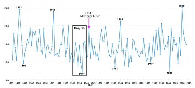
The three inches in 2001 and 25 inches in 2010 looked like once only events, but 1891 was also a Noah’s Arc year and was followed three years later by a low value.
The 1930s do not really look all that bad, except for 1937. But 1937 fell on the heels of low precipitation in 1936. My Dad always said they grew enough wheat in the 30s, they just never got paid for a crop when they did grow it.
1940 and ‘41 were also dry years. There are many stories of seeding the 1942 crop into dust. But then Mother Nature turned on the tap and the well known “Mortgage Lifter” year finally arrived.
Placed in context of a record of even a short time like 130 years, the events of the past few years do not appear so extreme.
Red river valley floods
Let me start off with a quiz. What year was the record flood for the Red River at Winnipeg?
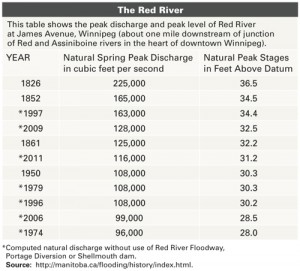 Some old folks might say 1950 and younger types could guess 1997. But, you would be very, very wrong (see at right).
Put in context of what Mother Nature did before humans had much influence, the events of recent decades seem quite tame.
In his 1860 report of his 1958 expeditions, Henry Youle Hind had this to say about 1852 “According to the Crees who hunt on this river, the whole valley (Qu’Appelle) from the Sandy Hills (Elbow) to the Assiniboine was converted to a lake in 1852, a year memorable in Rupert’s Land for its extraordinary humidity.”
After the 1950 flood the old data was examined and resulted in the floodway being increased to handle a much greater flow than 1950. The 1997 flood was dangerously close to the limit. Without the old data it could have been a disaster of much greater magnitude. I suspect we have the Hudson Bay Co folks to thank for that old data. (Note: Further interesting reading is St George and Rannie, 2003. “Canadian Water Resources Journal,” Vol. 28, No. 1, 2003.)
But the 1826 flood was the grandaddy of them all. What farm drainage do we blame that flood on?
Please do not get me wrong — if farm drainage in Saskatchewan is dumping on Manitoba farms or other property then changes need to be made. But, I have yet to see the data that documents the situation.
Who has assembled the flow records from the border stations operated by PPWB?
Who has traced flows back to large areas of wildcat drainage?
Who has studied the air photos to document where the drainage is taking place?
Again, we need a rifle approach not a shotgun.