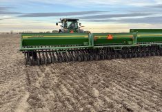
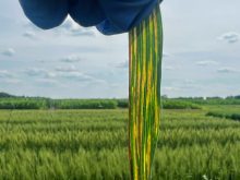
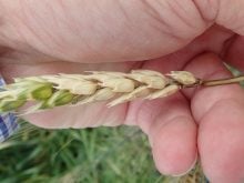
Wheat, barley and durum growers in all three Prairie provinces can now check online whether fusarium head blight may be coming soon to a field near them.
We’ve written before in these pages about the development and expected launch of new Prairie-wide fusarium head blight (FHB) risk maps — which have now gone live online effective May 15.
The mapping project was three years in the making, spearheaded by Dr. Paul Bullock at the University of Manitoba, with support from the three Prairie provincial ag ministries as well as Sask Wheat, SaskBarley, Alberta Grains and the Manitoba Crop Alliance.
Read Also
India likely to triple lentil import duty
Analysts anticipate India hiking duties to 30 per cent after March 31 to bolster domestic prices on expectation of strong harvest.
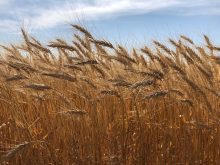
The maps allow growers to chart the risk of FHB, fusarium-damaged kernels (FDK) and deoxynivalenol (DON) for specific varieties, given the weather conditions. The risk mapping tool is publicly available and can be viewed on smartphones, tablets and desktop computers.
The weather-based risk is calculated using real-time data from more than 500 stations operated by Environment Canada, the Manitoba AgWeather Program, Saskatchewan Public Safety, Alberta Climate Information System and Metos Canada.
The risk algorithms used to create the maps are “homegrown,” the partners say, based on research data collected from 600 plot sites across 15 locations in Western Canada each year from 2019 through 2021 and tested in more than 300 producer fields on the Prairies during the same period.
By comparison, previous provincial FHB risk maps used “imported” risk algorithms with limited accuracy testing and couldn’t assess risk in barley or durum, nor for either FDK or DON. The risk mapping tool is publicly available and accessible using a smartphone, tablet or desktop computer.
Risk for disease severity can vary considerably by location and year, because of variable weather during the lead-up period prior to flowering — and that means the need to apply fungicide for disease control at a given location also varies from one extreme to the other, the project partners say.

It’s worth noting that the risk level estimated for a given area on these maps doesn’t mean every field in that area will experience such risk. However, the partners say, there’s “a good chance that the risk level indicated on the map for any crop on any specific day will match field observations.”
Wheat, barley and durum growers will still want to run field-level survey validation before deciding on whether to apply fungicides.
“The project is a great example of multi-institutional collaboration, where the combined skills and talents of both federal and provincial agricultural personnel, plus university collaborators, has facilitated research outcomes that could not have been achieved otherwise,” Martin Scanlon, the U of M’s dean of agriculture, said in the May 15 launch release. — D.B.